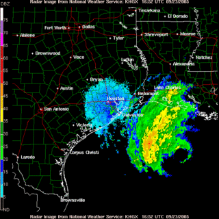
AT 7 AM EDT...1200Z...The storm keeps tracking to the East, putting more and more of Louisiana under the gun. It definitely seems as though Rita will finish what Katrina started. However, more people are actually heeding the warnings to get out of the way of this storm than they did before Katrina because of what they saw happen with the disaster response and the sheer level of destruction all along the Gulf Coast.
THE CENTER OF HURRICANE RITA WAS LOCATED NEAR LATITUDE 27.1 NORTH...LONGITUDE 91.5 WEST OR ABOUT 260 MILES SOUTHEAST OF GALVESTON TEXAS AND ABOUT 220 MILES SOUTH-SOUTHEAST OF CAMERON LOUISIANA.
RITA IS MOVING TOWARD THE NORTHWEST NEAR 9 MPH...AND THIS GENERAL MOTION IS EXPECTED TO CONTINUE FOR THE NEXT 24 HOURS. ON THIS TRACK...THE CORE OF RITA WILL BE APPROACHING THE SOUTHWEST LOUISIANA AND UPPER TEXAS COASTS LATE TODAY OR TONIGHT.
MAXIMUM SUSTAINED WINDS ARE NEAR 140 MPH...WITH HIGHER GUSTS. RITA IS AN EXTREMELY DANGEROUS CATEGORY FOUR HURRICANE ON THE SAFFIR-SIMPSON SCALE. SOME FLUCTUATIONS IN STRENGTH ARE EXPECTED DURING THE NEXT 24 HOURS.
HURRICANE FORCE WINDS EXTEND OUTWARD UP TO 85 MILES FROM THE CENTER...AND TROPICAL STORM FORCE WINDS EXTEND OUTWARD UP TO 205 MILES.
THE MINIMUM CENTRAL PRESSURE JUST ESTIMATED FROM AIR FORCE RESERVE HURRICANE HUNTER AIRCRAFT DATA WAS 930 MB...27.46 INCHES.
COASTAL STORM SURGE FLOODING OF 15 TO 20 FEET ABOVE NORMAL TIDE LEVELS...ALONG WITH LARGE AND DANGEROUS BATTERING WAVES...CAN BE EXPECTED NEAR AND TO THE EAST OF WHERE THE CENTER MAKES LANDFALL. TIDES ARE CURRENTLY RUNNING ABOUT 2 FEET ABOVE NORMAL ALONG THE LOUISIANA...MISSISSIPPI AND ALABAMA COASTS IN THE AREAS AFFECTED BY KATRINA. TIDES IN THOSE AREAS WILL INCREASE TO 3 TO 5 FEET AND BE ACCOMPANIED BY LARGE WAVES...AND RESIDENTS THERE COULD EXPERIENCE COASTAL FLOODING. LARGE SWELLS GENERATED BY RITA WILL LIKELY AFFECT MOST PORTIONS OF THE GULF COAST.
The changing path of Rita has offered some relief in the oil markets, as the price has stabilized with the area around Galveston looking to be spared the worst of the damage, though that may be premature thinking.
Houston hospitals are preparing for landfall. Many hospitals along the Gulf Coast have evacuated patients further inland and have secured their facilities as best as they could against the impending landfall.
Meanwhile, people continue evacuating from the Gulf Coast, and tragedy struck as a bus carrying some 45 eldery passengers caught fire, and at least 20 dead. The bus caught fire on I45, and has led to a renewal in the massive traffic jams that the region saw yesterday.
There were indications that oxygen used by elderly evacuees could have had a role in the fire, Peritz said. There were a series of explosions, apparently from the oxygen equipment, he said.The traffic had eased overnight, but this fire will definitely increase the tenseness of the situation for the tens of thousands who are trying to get out of the way.
"The early indications are this is a mechanical issue. The driver did survive the accident," Peritz said. "It's my understanding he went back on the bus several times to try to evacuate people."
Interstate 45 stretches more than 250 miles from Galveston through Houston to Dallas. The crash site is roughly 17 miles southeast of downtown Dallas.
UPDATE:
Brendan Loy weighs in with some thoughts and observations about Rita not wanting to make up its mind about where it wants to make landfall. He also notes that the storm surge will be quite severe, even if it comes ashore as a category 3 storm, though it is likely to remain a category 4 storm until landfall.
The death toll from the bus fire now stands at 24.
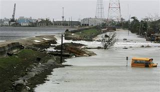
With the path pushing Rita closer to the Louisiana/Texas border, there are fears that the rainfall from Rita could overwhelm the levees and reflood the city of New Orleans. Good thing then, that Mayor Nagin decided to evacuate the city after waffling and complaining that the federal government was overstepping its authority in going public with calls that the city not be repopulated starting last week.
The forecast called for 3 to 5 inches of rain in New Orleans in the coming days. That is dangerously close to the amount engineers said could send floodwaters pouring back into neighborhoods that have been dry for less than a week.'
The storm took a sharper-than-expected turn to the right on Thursday, setting it on a course that could spare Houston and nearby Galveston a direct hit. But that raised the risk that the hurricane could strike much closer to New Orleans.
FEMA has finally opened up a center in Slidell, though FEMA officials note that federal assistance has been pouring into the parish since the storm hit. The problem is that they admit that they've been stretched real thin. That isn't a good sign with Rita expected to come ashore in its full fury within the next 24 hours.
UPDATE:
Anxiety grows in Louisiana:
"Rita has Louisiana in her sights," Blanco said. "Head north. You cannot go east, you cannot go west. If you know the local roads that go north, take those."At least some folks have learned the hard way that they need to take decisive action. Katrina was definitely a wake up call to health care facilities in the path of Rita, as they're doing the prudent thing by getting them out of harms' way, though we see with the bus fire, that even this has its dangers.
As for those who refuse to leave, she said: "Perhaps they should write their Social Security numbers on their arms with indelible ink."
Of particular concern were the major population centers of Lake Charles (72,000 people) and, to a lesser degree, Lafayette (110,000 people).
The governor said she had been told to expect a 15- to 20-foot storm surge in Vermilion Bay, south of Lafayette.
Don Smithburg, chief of the Louisiana State University hospital system, the state's public hospitals, said he evacuated the critical care patients from the hospital in Lake Charles ahead of Hurricane Rita on Wednesday and was in the process of evacuating the rest Thursday.
"We're not waiting for somebody else to give us the high sign," he said. "We are taking matters into our own hands."
National Guard and medical units were on standby. Helicopters were being positioned, and search-and-rescue boats from the state wildlife department were staged on high ground on the edge of Rita's projected path. Blanco said she also asked for 15,000 more federal troops.
Water is already pooling in the 9th Ward in New Orleans. Areas that were dry a day ago are seeing a foot of standing water, which is a combination of rains and seepage through the weakened levee system.
UPDATE:
Michelle Malkin is reporting that one of the levees has been overtopped, and may be breached altogether if the storm tracks further to the east.
Confederate Yankee was kind enough to point out that WRAL-TV in Raleigh, NC, has put together a good listing of Texas and Louisiana media outlets, webcams and blogs that I thought you might find useful if you want to use them to follow Hurricane Rita from a local perspective.
http://www.wral.com/weather/5008193/detail.html
I hope it is of use to you.
UPDATE:

UPDATE:

UPDATE:
Rita has been downgraded to a strong Category 3 storm. Good news for the Gulf Coast, but only by a matter of degree. There's still time before landfall, rainfall is already washing over Louisiana and there may be significant flooding in New Orleans before the main of the storm comes ashore.
Don Surber cautions against comparing the Katrina and Rita evacuation and responses. They were different situations and different challenges mean different solutions.
Meanwhile, over at Wizbang, Paul is wondering whether Baghdad Bob has taken over at the Army Corps of Engineers (just keep scrolling).
Technorati: flood aid; hurricane katrina; hurricane rita; katrina aid; new orleans, rita, galveston, lake charles, levee; levee breach.
No comments:
Post a Comment